
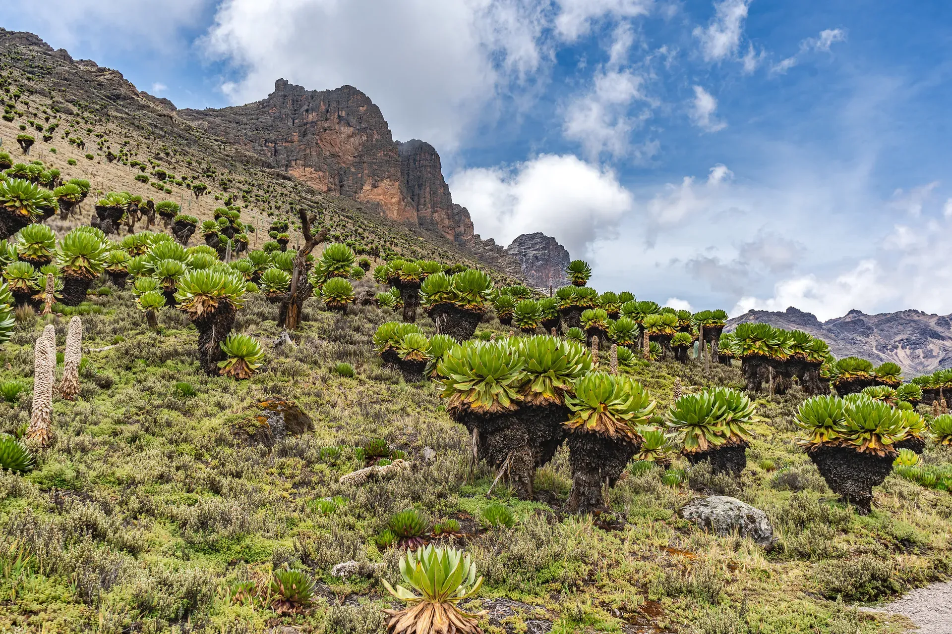
Mount Kenya is an extinct stratovolcano straddling the equator 193 kilometers north-northeast of Nairobi. It is Africa's second-highest mountain, rising to 5,199 meters and supporting rare afro-alpine ecosystems and 12 remnant glaciers.
Mount Kenya is an extinct stratovolcano in central Kenya, located 193 kilometers north-northeast of Nairobi. It is the second-highest mountain in Africa, trailing only Kilimanjaro. The central peaks—Batian (5,199 meters), Nelion (5,188 meters), and Point Lenana (4,985 meters)—rise directly from the equator. The mountain gives the Republic of Kenya its name. Mount Kenya National Park and the surrounding forest reserve protect the upper slopes, forming a UNESCO World Heritage Site and Biosphere Reserve. The park boundaries encompass 715 square kilometers, while the adjacent forest reserve covers another 705 square kilometers.
The mountain functions as a massive water tower for the region. It supplies water to roughly half of Kenya's population and generates 70% of the country's hydroelectric power through the Tana River catchment. Visitors encounter a sharp vertical gradient of ecosystems as they ascend. The lower slopes are covered in montane rainforest and dense bamboo belts that trap moisture from the Indian Ocean. Above 3,000 meters, the terrain shifts to afro-alpine moorland characterized by giant lobelias and groundsels. The highest elevations are stark alpine desert, containing roughly 20 glacial tarns and 12 rapidly receding glaciers. These ice formations are expected to disappear entirely within the next few decades.
Trekking routes approach the peaks from different sides, each with distinct terrain. The Sirimon route covers 29 kilometers of gradual ascent from the northwest, making it the most popular path for acclimatization. The Naro Moru route spans 25 kilometers on the western side and includes a steep, waterlogged section known as the Vertical Bog. The 40-kilometer Chogoria route approaches from the east past Nithi Falls and the sheer cliffs surrounding Lake Michaelson. Most hikers target Point Lenana, as Batian and Nelion require technical multi-pitch rock climbing. The park operates as a strict plastic-free zone, and hikers must hire a licensed KWS guide for any ascent above the forest line. Gate entry requires digital payment via the eCitizen platform, as rangers no longer accept cash.
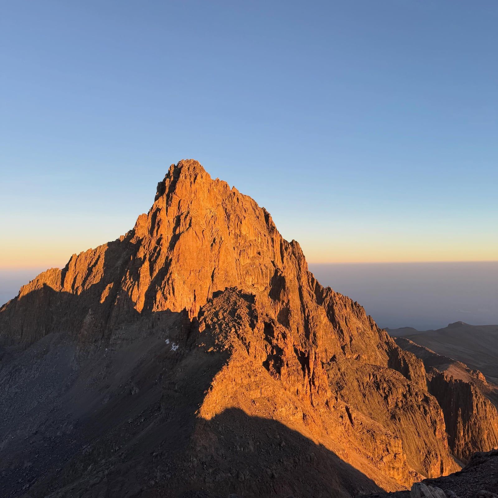
Mount Kenya formed as a stratovolcano between 3.1 and 2.6 million years ago during the opening of the East African Rift. Geologists estimate the original peak reached 6,500 meters before extensive glaciation and erosion stripped away the upper cone. This destructive process left behind the jagged syenite and phonolite plugs of Batian and Nelion that define the summit today. The mountain held massive ice caps during the Pleistocene epoch. These thick ice sheets carved the deep U-shaped valleys radiating from the peaks and scoured out the basins for roughly 20 glacial tarns found between 3,950 and 4,800 meters.
European exploration of the high peaks began in the late 19th century, though local communities had lived on the lower slopes for centuries. Sir Halford John Mackinder, Cesar Ollier, and Josef Brocherel completed the first recorded ascent of Batian on 13 September 1899. They spent weeks cutting through the bamboo forests and crossing the glaciers with a large team of local porters. The second-highest peak, Nelion, remained unclimbed for another three decades due to its sheer rock faces. Eric Shipton and Percy Wyn-Harris finally reached its summit on 6 January 1929. They also mapped several of the high-altitude tarns and glacial features during their expedition.
The colonial government gazetted the Mount Kenya Forest Reserve in 1932. This designation aimed to manage timber extraction and protect the critical watershed that fed the surrounding agricultural lands. Mount Kenya National Park followed in 1949, establishing formal protection for the ecosystems above the 3,200-meter contour line. During the 1950s Mau Mau Uprising, fighters led by Dedan Kimathi used the dense forests and caves of Mount Kenya as hideouts and operational bases against British colonial forces. The rugged terrain made it nearly impossible for conventional troops to flush them out.
International recognition expanded in the late 20th century as the mountain's ecological value became clearer. UNESCO designated the mountain a Biosphere Reserve in 1978 and inscribed it as a World Heritage Site in 1997. The Kenyan government upgraded adjacent forest reserves to National Reserves in 2000 to strengthen the buffer zone against illegal logging and poaching. Today, the 12 remaining glaciers are receding rapidly due to climate change. Conservation efforts now focus on maintaining the 9.8-kilometer elephant corridor connecting the mountain to the Lewa Wildlife Conservancy and Ngare Ndare Forest Reserve to the north. This corridor allows large mammals to migrate safely between the highland forests and the lowland savannas.
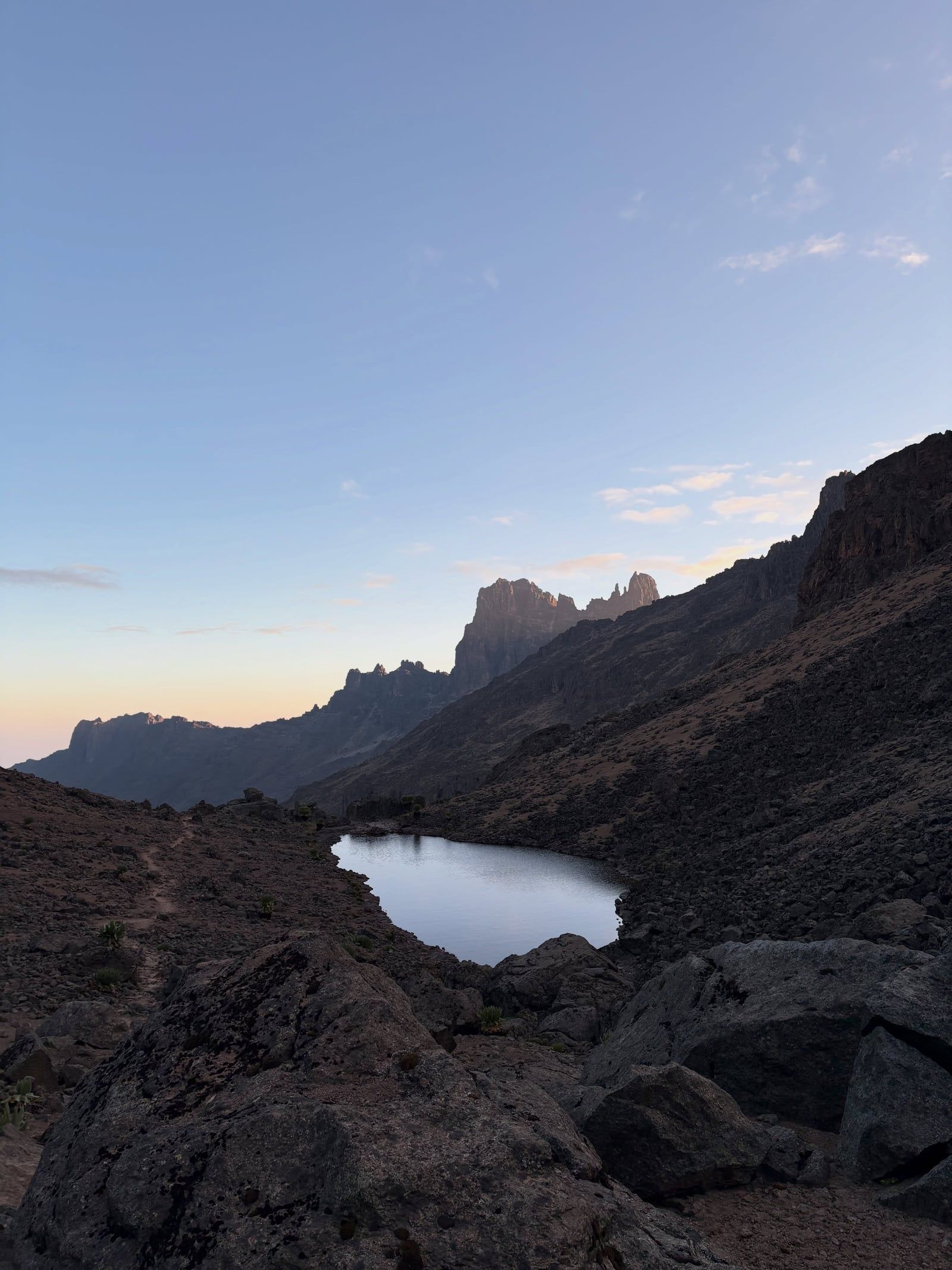
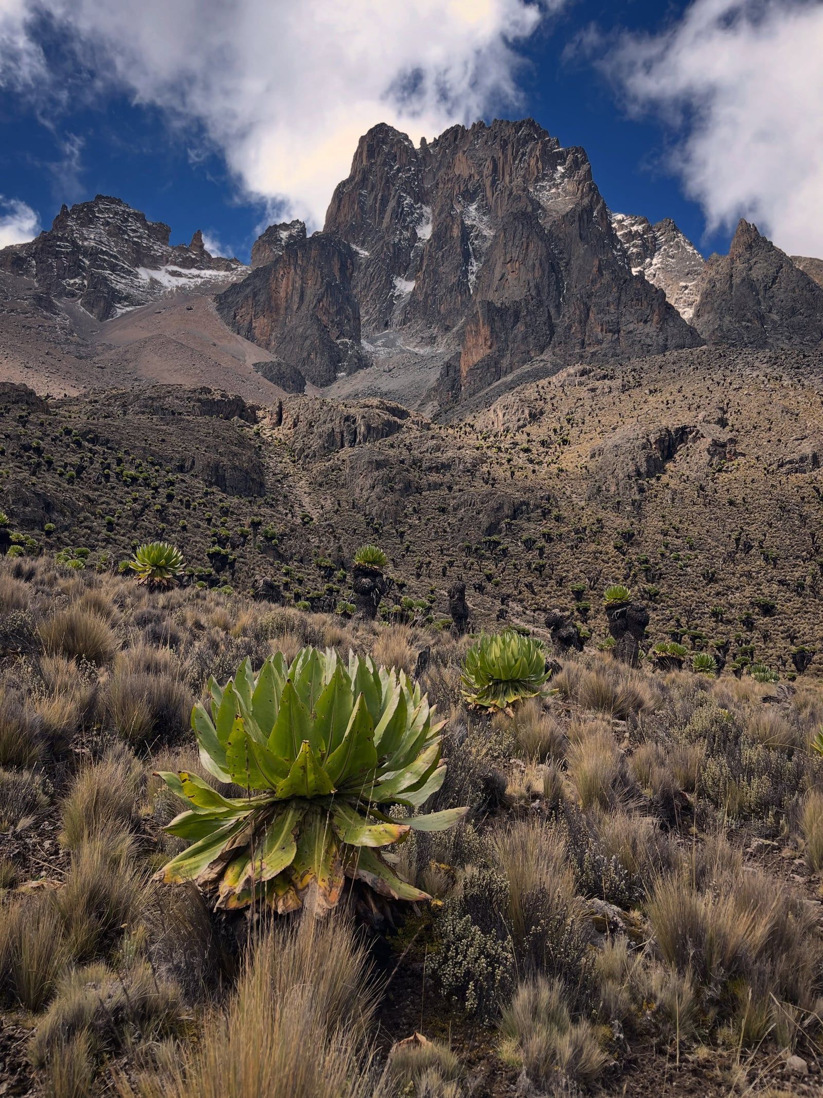
Mount Kenya is a heavily eroded volcanic plug surrounded by distinct ecological bands. The summit consists of hard syenite and phonolite rock, exposed after millions of years of glacial action stripped away the original crater. Four secondary peaks sit at the head of deep, U-shaped glacial valleys that radiate outward from the center like the spokes of a wheel. Twelve remnant glaciers cling to the upper slopes. The Lewis Glacier is the largest, though it is losing mass rapidly. The terrain holds roughly 20 glacial tarns—small, ice-carved lakes—scattered between 3,950 and 4,800 meters. Lake Michaelson, located on the Chogoria route, sits at the bottom of a 200-meter cliff known as the Temple.
The mountain's vegetation grows in sharp altitudinal zones dictated by temperature and rainfall. The base is ringed by montane rainforest, which transitions into a dense bamboo belt at around 2,500 meters. Above the tree line at 3,000 meters, the afro-alpine moorland begins. This zone contains endemic giant groundsels and lobelias. These plants grow several meters high and close their leaf rosettes at night to protect their central buds from freezing temperatures. The Naro Moru route crosses a section of this moorland known as the Vertical Bog. This steep slope of waterlogged tussock grass tests trekkers with thigh-deep mud after heavy rains. Above 4,000 meters, the vegetation thins into stark alpine desert, where only hardy mosses and lichens survive the freezing nights and intense equatorial UV radiation.
The lower forests support isolated populations of large mammals. Forest elephants, black rhinoceroses, leopards, and giant forest hogs inhabit the dense cover. The mountain is also a refuge for the critically endangered mountain bongo. Fewer than 150 of these large, striped forest antelopes remain in the wild, scattered across four isolated populations. Higher up, the moorlands host specialized species like the Mount Kenya mouse shrew and the rock hyrax. The hyrax, despite resembling a large guinea pig, is the closest living relative to the elephant. The entire ecosystem connects northward via a 9.8-kilometer corridor to the Lewa Wildlife Conservancy. This underpass beneath the Nanyuki-Meru highway allows elephants to migrate between the mountain and the savanna without crossing vehicle traffic.
The climate on Mount Kenya changes drastically throughout the day. Temperatures at the base average 25 degrees Celsius, while the summit frequently drops to minus 5 degrees Celsius at night. The mountain creates its own weather system. Mornings are typically clear and cold, providing unobstructed views of the plains below. By early afternoon, warm air rising from the lowlands condenses into thick fog and rain clouds around the peaks. Trekkers time their summit pushes for 3:00 AM to reach Point Lenana at sunrise, avoiding the afternoon whiteouts. The long rains fall from March to May, turning the trails into impassable mud, while the short rains in November bring sudden, heavy downpours.
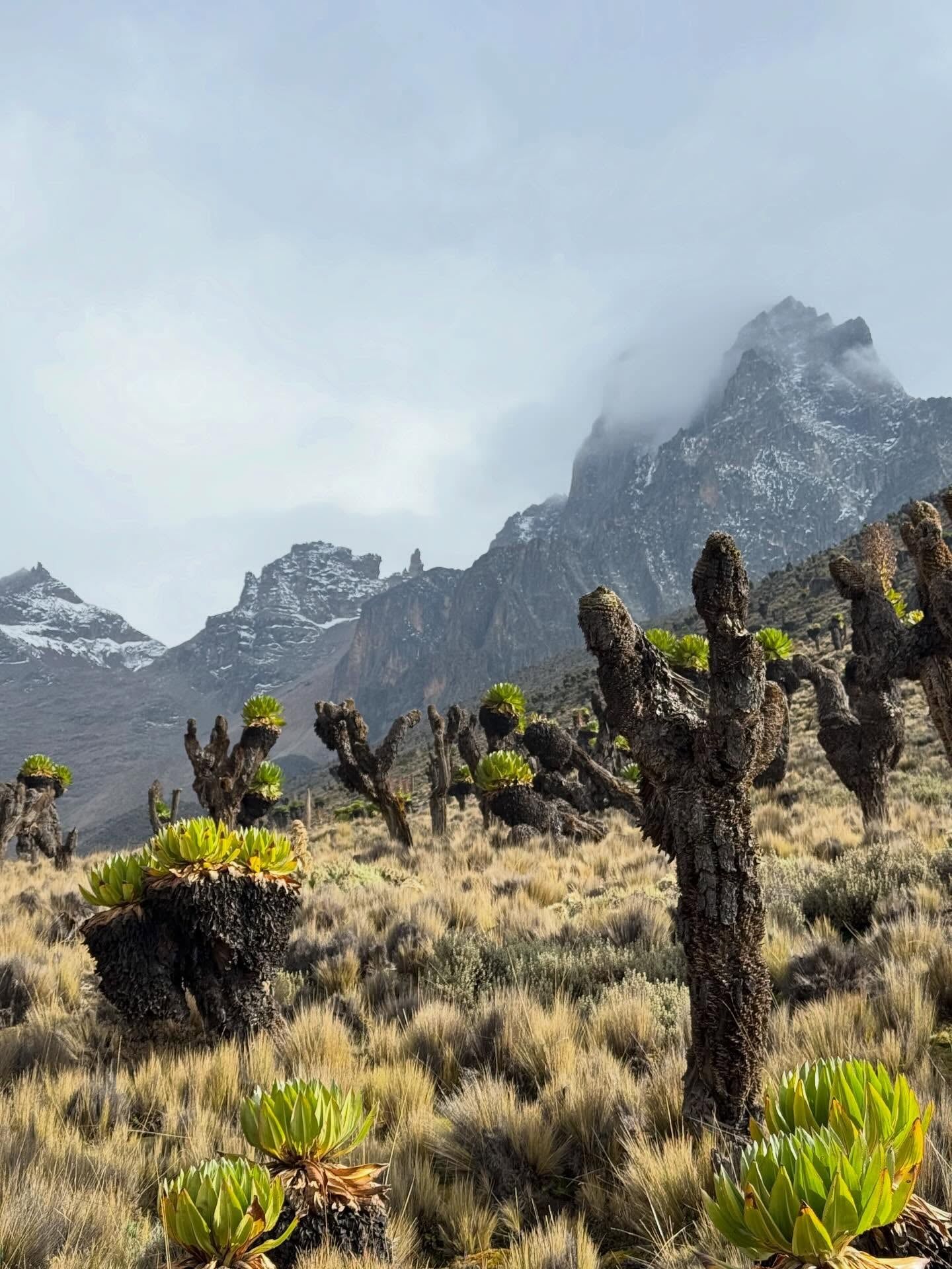
Mount Kenya is a holy site for the Kikuyu, Meru, and Embu peoples who live on its lower slopes. The Kikuyu call the mountain Kirinyaga, meaning the mountain of whiteness or the mountain of light. Traditional belief holds that the supreme creator, Ngai, and his wife Mumbi reside on the highest peaks. Kikuyu communities historically built their homes with the main doors facing the mountain. Elders conducted prayers, rainmaking ceremonies, and sacrifices at designated sacred sites in the forest, always facing the snow-capped summits. The mountain dictates the agricultural calendar, as its peaks catch the rain clouds that water the fertile volcanic soils below.
The mountain is the namesake of the Republic of Kenya. It functions as the primary water source for the surrounding agricultural lands and the distant capital. The rivers flowing from its glaciers and forests feed the Tana River, which supplies water to millions of people and powers the country's major hydroelectric dams. The health of the mountain directly dictates the economic and physical survival of communities hundreds of kilometers away. Deforestation on the lower slopes immediately impacts water levels in reservoirs downstream, making the mountain's conservation a matter of national security.
Local guides and porters from nearby towns like Nanyuki, Naro Moru, and Chogoria manage the trekking industry. A KWS-licensed guide is mandatory for all ascents above the forest gates. These crews move through the complex microclimates and carry supplies up to stone shelters like Mackinder's Camp and Shipton's Camp at 4,200 meters. Their knowledge of the terrain prevents fatal errors in an environment where oxygen levels drop by 40 percent and temperatures routinely fall below freezing. Many guides are second or third-generation mountaineers, inheriting route knowledge and acclimatization techniques from their parents. They enforce park rules, ensuring visitors pack out all waste and avoid cutting live wood for fires.
Mount Kenya has 12 remnant glaciers, but they are melting rapidly and expected to disappear entirely within a few decades.
A 9.8-kilometer elephant corridor connects the mountain's forests to the Lewa Wildlife Conservancy, allowing wildlife to migrate safely.
The mountain generates 70% of Kenya's hydroelectric power and supplies water to half the country's population.
The highest peaks, Batian and Nelion, require technical rock climbing, so most trekkers summit Point Lenana at 4,985 meters instead.
The lower forests provide habitat for the critically endangered mountain bongo, a forest antelope with fewer than 150 individuals left in the wild.
The original volcano is estimated to have reached 6,500 meters before millions of years of erosion reduced it to its current height.
The entire national park is a strict plastic-free zone, banning all single-use plastic bottles and bags.
Non-resident adults pay USD 70 for a 24-hour ticket. East African citizens pay KES 800, and Kenyan residents pay KES 1,100. All payments must be made digitally through the eCitizen KWSPay platform, as gates do not accept cash.
Yes. Hiking alone is prohibited in the national park. You must hire a KWS-licensed guide for any trek, and technical summits require a separate mountain climbing permit.
The dry seasons from January to March and June to October offer the best conditions. The long rains from March to May and short rains in November make trails muddy, slippery, and sometimes impassable.
A standard trek to Point Lenana takes four to six days round trip. Technical climbs to Batian or Nelion require six to eight days. Day visitors can explore the lower forest zones for a few hours.
Batian is the highest peak at 5,199 meters. Nelion is second at 5,188 meters, and Point Lenana is third at 4,985 meters.
Beginners with good fitness can trek to Point Lenana (4,985 meters). The higher peaks of Batian and Nelion are strictly for experienced rock climbers. Altitude sickness is a risk on all routes above 3,000 meters.
The three primary routes are Sirimon, Naro Moru, and Chogoria. Sirimon is the most gradual, Naro Moru is the shortest and steepest, and Chogoria is the longest but most scenic.
You can take a matatu or bus from Nairobi to Nanyuki or Chogoria, which takes four to five hours. Alternatively, scheduled flights run from Nairobi's Wilson Airport to the Nanyuki airstrip in 40 minutes.
The lower montane forests host elephants, black rhinos, leopards, giant forest hogs, and mountain bongos. The high-altitude moorlands are home to rock hyraxes and the endemic Mount Kenya mouse shrew.
Yes, it is an extinct stratovolcano. It was active between 2.6 and 3.1 million years ago before glacial erosion wore away the original crater, leaving the jagged rock spires seen today.
Browse verified tours with free cancellation and instant confirmation.
Find Tours